Soil Erosion: Southern Africa's water tower is endangered
Wind and water carry away fertile topsoil both in montane and lowland regions, the equilibrium of important wetlands is distrubed. More attention should be paid to regeneration.
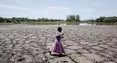
Soil erosion in Southern Africa stands out as one of the most important environmental challenges, posing a threat to food and water security. In the region, over 70% of productive land is affected by various forms of erosion (Le Roux et al., 2007). Typically, it is the fertile topsoil that undergoes erosion due to wind and water, carrying away substantial amounts of nutrients and organic carbon. This degradation results in a reduction and sometimes a collapse of essential ecosystem functions provided by soils, such as supporting plant growth, water purification, and facilitating the existence of a diverse array of organisms. Linked to this degradation are environmental and infrastructural problems such as the eutrophication of water sources, sedimentation of reservoirs, infrastructure destruction, loss of baseflows, and reduced vegetative production.
In South Africa, soil wind erosion frequently occurs in the drier western parts of the country and is closely linked to the natural and human-induced removal of vegetation cover. More than 25% of South Africa is susceptible to wind erosion (Pretorius, 1998), especially in the Northern Cape, and the western parts of the Free State and North-West Provinces. The areas prone to wind erosion are likely to expand due to the loss of vegetation in rangelands and tillage practices in agricultural lands.
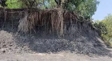
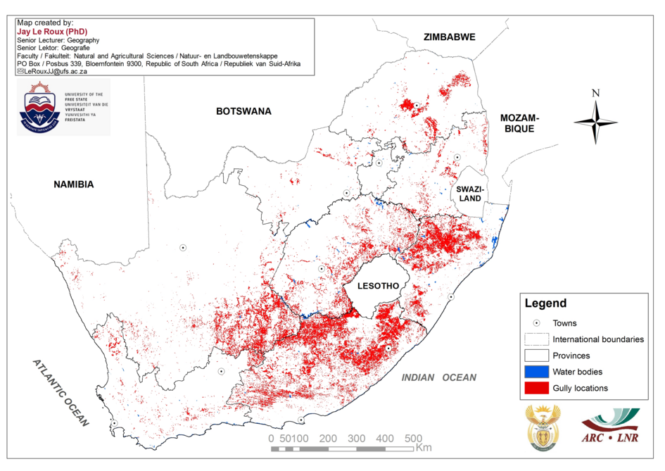
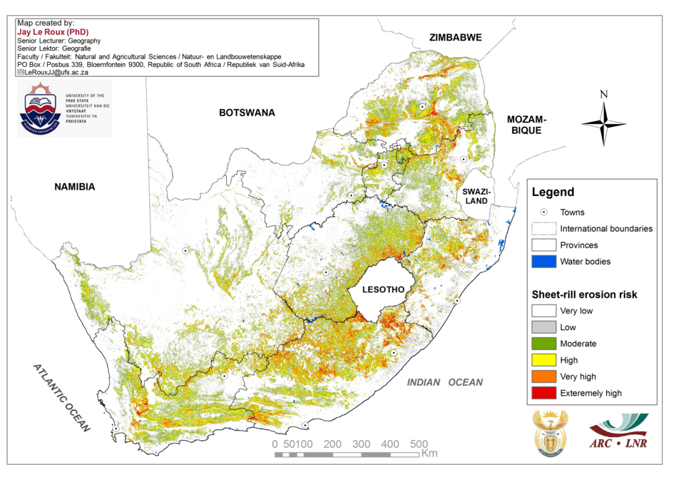
Sheet, rill, and particularly gully erosion in the interior of Southern Africa lead to considerable soil loss (Figure 1). Mararakanye and le Roux (2012) mapped over a 150,000 gully erosion features in South Africa ranging from just a few cubic metres to several hectares each. Prior to above-mentioned study, a soil erosion model, known as the Universal Soil Loss Equation, was used by le Roux et al. (2008) to estimate rainfall erosion in South Africa. The results emphasize sheet and rill erosion and illustrate that areas classified as having a moderate to high erosion risk when the average annual soil loss rate exceeds 12 t/ha/yr. In this context, the Eastern Cape (6 188 581 km2) is the most severely affected province. Quantitative estimations predict losses of around 12.6 tons/ha/year in South Africa. Given that the natural soil formation rate is less than 5 tons/ha/year, it is evident that more soil is exported than gained.
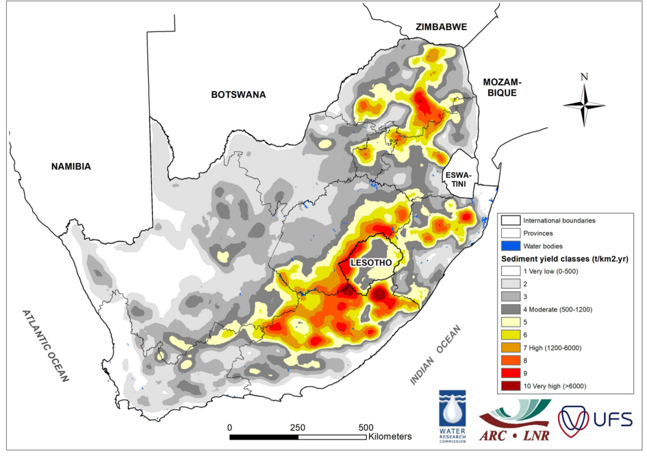
Given the increasing threat of reservoir siltation, the Water Research Commission (WRC) identified the need to improve the original sediment yield map of South Africa (Rooseboom et al. 1992). Subsequently, a revised sediment yield map was produced using latest reservoir sediment deposition data in probabilistic and empirical modelling (Msadala et al. 2010). Figure 3 illustrates that the highest sediment yields are predicted in the eastern parts of the country including the lowlands of Lesotho.
The underlying geology is part of the Beaufort sediments of the Drakensberg group. Some of these lithological layers have very high sodium concentrations. Excessive sodium causes a dispersion of soil particles, making them extremely vulnerable to water erosion. Mismanagement, for instance through overgrazing and unsustainable tillage practices, results in severe degradation of these sensitive soils.
The political legacy of Apartheid and the associated 'Homeland system' led to a relative overpopulation in former homelands in mountainous regions with sensitive soils (e.g., Transkei and QwaQwa). The unsustainable and forceful influx of people and livestock onto these inherently erosion-susceptible soils was a recipe for disaster, and these areas remain some of the most degraded systems in Southern Africa.
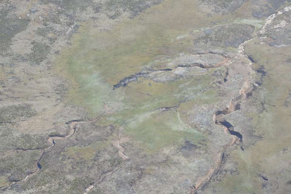
The lowlands of Lesotho share the same sensitive geological formation as surrounding South Africa (Figure 2). The majority of the population inhabits these lowlands to escape the harsh, cold climate of the highlands. On these communal lands, dedicated grazing plans are seldomly implemented, and overgrazing near villages is widespread. Consequently, substantial portions of the lowlands have been severely degraded by water erosion. The degradation, stemming from overpopulation and a lack of landownership, is often encapsulated in the “tragedy of the commons” narrative (Harding, 1968).
Water Security under Threat
The degradation of montane and alpine wetlands in the Maloti-Drakensberg region of South Africa and Lesotho is likely one of the greatest threats to water security in water-scarce Southern Africa. The Maloti-Drakensberg serves as a water tower regulating the water supply to Southern Africa, particularly through major rivers and water infrastructure like the Senqu/Orange system and the Lesotho Highlands Water Project (LHWP), which provides water to the economic hub of southern Africa in Gauteng, South Africa, as well as Botswana and Namibia.
The alpine wetlands play significant roles in ecosystem functions, including flood attenuation, sediment and toxin retention, organic carbon sequestration, groundwater storage and recharge, and providing a habitat for endemic species and unique vegetation communities. However, they are undergoing alarming degradation. Reports estimate that between 20 and 50% of wetlands have disappeared in the past 30 years, and those that remain are storing considerably less water.
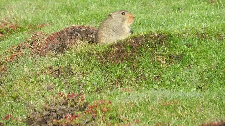
Several factors contribute to their degradation, including overgrazing, poor infrastructure planning (especially the road network), the activity of the ice rat (Otomys sloggetti robertsi) (Title Picture), and climate change. However, there is a lack of baseline background information to definitively determine which factors are driving the degradation.
While significant efforts have been dedicated to the restoration of degraded alpine wetlands, historical approaches have been characterized by a fragmented, project-specific methodology. The predominant focus has been on the implementation of hard structures within the wetlands (Figure 4d), overlooking the critical aspect of addressing the fundamental causes of degradation. The degraded or degrading wetlands are often the symptom of a mismanaged landscape.
Can Degradation be stopped?
Without a comprehensive understanding and assessment of the contributing factors, tackling the root issues becomes an intricate challenge. To overcome this lack of baseline understanding, a Long-Term Socioecological Research (LTSER) platform has been established in the Maloti-Drakensberg (Kotze et al., 2023). This is Africa’s first alpine and transboundary LTSER with research on wetland and rangeland degradation as a primary focus.
In addition, a recent initiative, known as RE NOKA (meaning "we are river"), has been launched in Lesotho, receiving partial funding from the Lesotho government and GIZ. This project aims to adopt an integrative catchment management approach (ICM) for the restoration of wetlands across various regions in Lesotho. The conviction is that sustainable restoration can only be achieved through the comprehensive framework of ICM where the entire catchment is managed sustainably.
This would include, for example, restoration of rangelands and employing grazing management strategies, reduced tillage practices and recognising the need for local communities to actively drive the restoration. We are convinced that if such an ICM approach is coupled with holistic baseline understanding and characterising of the mechanisms driving degradation, these causes could be adequately arrested. This could restrict further degradation and restoration of ecosystem services in these important landscapes.


References:
Hardin G., 1968. The tragedy of the commons. Science. 162:1243–1248.
Kotze, J.J., van Tol, J.J. & Clark, V.R., 2023. Africa’s First Alpine and Transboundary Long-Term Socioecological Research Platform. 43(3). Mountain Research and Development. doi.org/10.1659/mrd.2023.00035.
Le Roux, J.J., Newby, T., Sumner, P., 2007. Monitoring soil erosion in South Africa at a regional scale: review and recommendations. South Afr. J. Sci. 103, 329 - 335.
Le Roux, J.J., Morgenthal, T.L., Malherbe, J., Sumner, P.D., Pretorius, D.J., 2008. Water erosion prediction at a national scale for South Africa. Water SA 34(3), 305-314. ISSN 1816-7950.
Mararakanye, N., Le Roux, J.J., 2012. Gully erosion mapping at a national scale for South Africa. South African Geographical Journal 94(2), 208-218. doi.org/10.1080/03736245.2012.742786.
Msadala, V., Gibson, L., Le Roux, J.J., Rooseboom, A. Basson, G.R., 2010: Sediment Yield Prediction for South Africa: 2010 Edition, WRC report 1765/1/10. ISBN 978-1-4312-0042-9. Water Research Commission: Pretoria, South Africa.
Pretorius DJ., 1998. The development of land degradation monitoring and auditing techniques with the aid of remote sensing and GIS technology. ISCW Report No. GW/A/98/27. National Department of Agriculture, Directorate Land and Resources Management, Pretoria.